You can use this free image under the Creative Commons Zero (CC0) public domain license. Support our free section by adding a credit line next to the photo in your design. A suggestion is provided under the title.
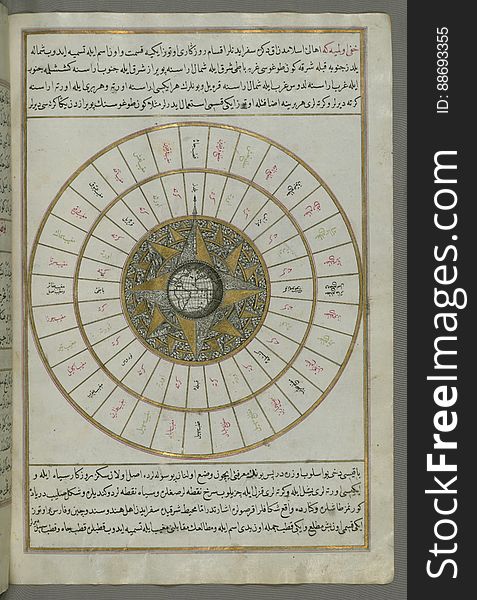
Illuminated Manuscript, Map of Western hemisphere within a windrose, from Book on Navigation, Walters Art Museum Ms. W.658, fol.24
Originally composed in 932 AH / 1525 CE and dedicated to Sultan Süleyman I ("The Magnificent"), this great work by Piri Reis (d. 962 AH / 1555 CE) on navigation was later revised and expanded. The present manuscript, made mostly in the late 11th AH / 17th CE century, is based on the later expanded version with some 240 exquisitely executed maps and portolan charts. They include a world map (fol.41a) with the outline of the Americas, as well as coastlines (bays, capes, peninsulas), islands, mountains and cities of the Mediterranean basin and the Black Sea. The work starts with the description of the coastline of Anatolia and the islands of the Aegean Sea, the Peloponnese peninsula and eastern and western coasts of the Adriatic Sea. It then proceeds to describe the western shores of Italy, southern France, Spain, North Africa, Palestine, Israel, Lebanon, Syria, western Anatolia, various islands north of Crete, Sea of Marmara, Bosporus and the Black Sea. It ends with a map of the shores of the the Caspian Sea (fol.374a). Virtually turn the pages of this entire manuscript on Walters Ex Libris Access high-resolution archival images of this manuscript and a complete manuscript description for free on the Digital Walters at purl.thewalters.org/art/W.922/browse
© publicdomainstockphotos | Stock Free Images